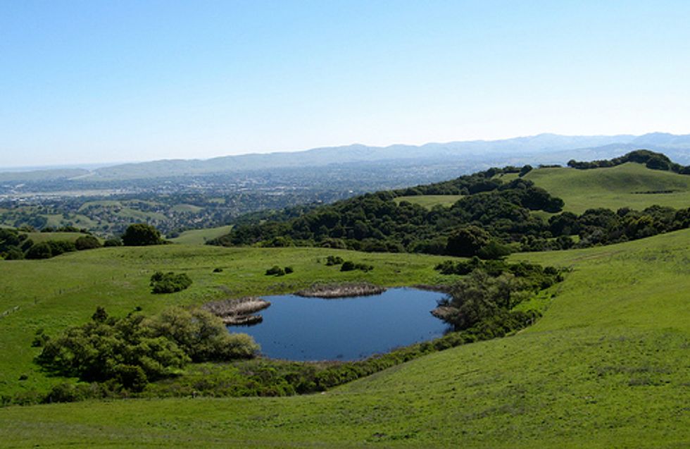
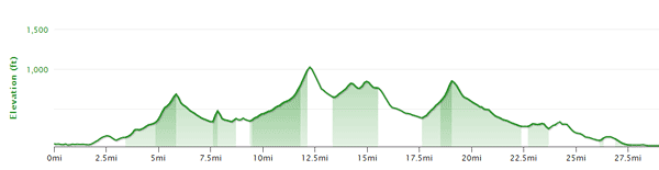
It might be said that for many Bay Area riders and residents, the East Bay is regarded as one giant mass of endlessly developed land that stretches to Livermore and beyond to I-5. However, within all that alleged sprawl there lies plenty of hidden parks, tranquil valleys and rural areas just waiting for your exploration. This particular ride provides an introduction to all three and takes us on a circumnavigation of Briones Regional Park, at 6100 acres one of the crown jewels of the East Bay park system. We won’t actual ride through the park (it’s only possible on a MTB) we hug its borders pretty closely in this 28 mile loop that will racks us up some 2800 feet of vertical and for much of the time will make you feel that you’re way out in the country.
We’ll begin the ride from the parking lot of the Concord Park and Shop Center at Market St. and Willow Pass Rd., easily accessible from both Highways 680 and 24.
Clip in and head East on Willow Pass, being mindful of the traffic as you go under I-680 and cross Contra Costa Blvd. At this point (1.25miles) the road becomes Taylor Blvd. and starts to turn South. At Grayson Rd. glide right ay the light (3.25miles) then make a left on Reliez Valley Rd. to start a short 7% climb that ends at mile six. A speedy descent onto Pleasant Hill Road (bearing right) gives a momentary break before a very short, but steep ascent up Deer Hill Road just before the Hwy. 24 interchange. This 125 foot, 11.2% bump will leave you gasping as you then head West parallel to the highway for a mile and a quarter. Make a right on Happy Valley Rd. where the road lives up to its name and life starts to get more tranquil. It may in fact get quiet enough to hear your raging heart beat as Happy Valley’s pitch steadily increases to 11% and reaching the high point for the ride at 1,024 feet. A fast and technical descent down the narrow backside ends with a long straightaway to the T-intersection with Bear Creek Road, at 13.25 miles in. Go right here, enjoying the wide shoulder and perhaps getting a glimpse of Briones reservoir to your left.
A quarter mile down the road brings us toWestern border of the park at the Bear Creek entrance. First timers to this area will appreciate the ability to escape the urban crunch so readily and may ponder a return visit to hike amongst these gorgeous hills. After some undulating rollers you’ll get a fast, 8% downhill as the road narrows and becomes a bumpier heading down to the junction with Alhambra Valley Rd. at 17.5 miles. As we turn back East towards Concord, this is when things really start feeling rural, with some working ranches still evident. A couple of miles further along, the last challenging climb up to Pig farm gives you your third 11 percenter of the day followed by a long and fast 3.3 mile exhale to the intersection with Reliez Valley Rd. where you’ll again bear right. Now suburbia will slowly become more intrusive. The more direct route back (our map above) is to make a left at Blue Ridge, bear right at Virginia Hills, the right again at Pleasant Hill and a left onto Taylor Rd. If you’d like to add a few more miles continue South on Reliez past Blue Ridge and make a left on Grayson back to Taylor Blvd. retracing the first part of the ride. Should you want to use public transit and make this ride without a drive to Concord, start at the Layfette BART (Dear Hill and Happy Valley).