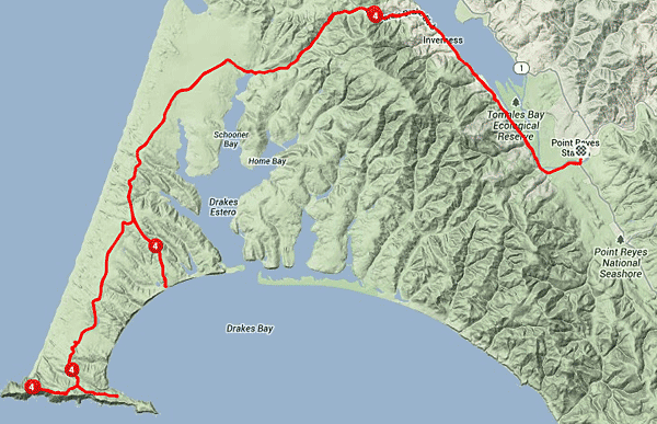
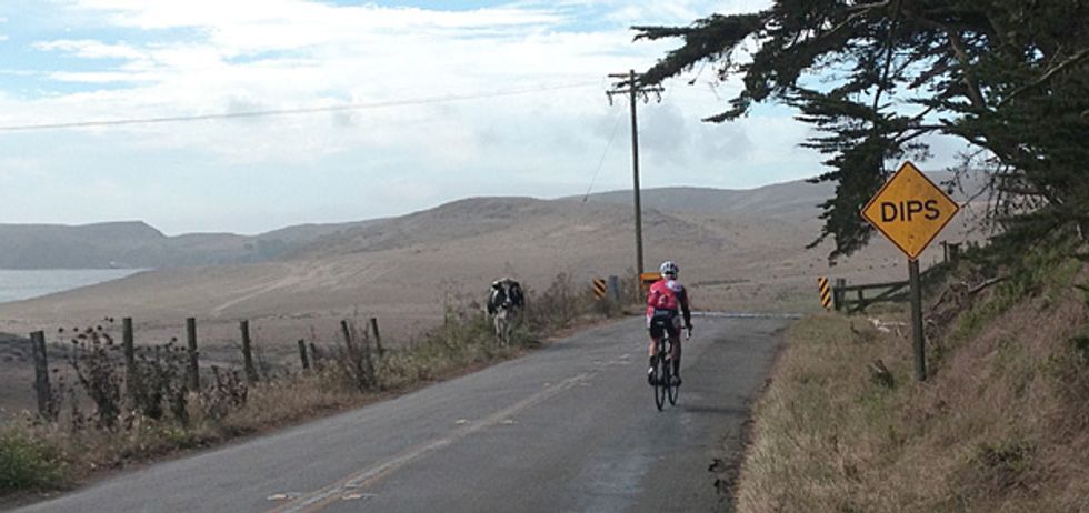
To take a ride out to the lighthouse on the Point Reyes Peninsula is to take a journey back in time. First lit on December 1, 1870 it has provided a steady beacon to sailors navigating the treacherous Pacific coast nearly 143 years. For today's ride, it stands as the western most point one can ride in Marin County. This is a challenging and worthwhile ride - the former due to numerous steep (but short) climbs and at times fierce wind and the later because of the outstanding vistas, rugged terrain and isolation. Autumn is great time to make this ride as the ocean fog can be minimal and with it diminished winds.
With an in and out of 45 miles, an early start is recommended from Point Reyes Station, giving a enough time (and incentive) for a rewarding lunch on your return. Head South out of town on Hwy.1 and make a right after crossing the bridge onto Sir Francis Drake Blvd. We'll be on this road the entire way out. It's an easy warm-up for the first 6 plus miles as we travel along the marshlands and shore of Tomales Bay. After Inverness (last chance for food and drink) the road turns west again and we hit our longest climb of the day up and over Inverness Ridge. A short time after the crest, bear left at the intersection as we speed downhill, passing the first of the many historic diary ranches. These were preserved in perpetuity for agriculture use when the Point Reyes National Seashore was established in 1962. Be aware that road becomes progressively rougher the further we get towards the lighthouse, with many cattle guards and patches of broken asphalt.
As we exit the gully that feeds Schooner Bay we climb back up into the rangeland and get some very sweet views to our left of the Drake's Estero and later, to the right, we can catch brief glimpses of the crashing surf of the gale facing North and South Beaches. At 14.5 miles bear right at the intersection with the road to Drakes Beach. Here begin the bothersome bumps, and after the last ranch, again bear right, culminating in a 240 foot 11% lunge up to the lighthouse parking area (there's a restroom here, but not water). As the views up here are spectacular, you may want to linger. Looking up towards Bodega Head in Sonoma the straight as an arrow sweep of the North and South Beaches is plainly evident. On clear days in October you might spot gray whales migrating south to breeding grounds in the Sea of Cortez.
Our maps shows a couple of detours for the return, the first takes us down to the historic lifeboat station but requires a rather dicey climb back out if there's a wind blowing. However the views are breathtaking to the East of the white cliffs that Sir Francis likened to those back home in Dover, England. The second detour is down to base of those very same cliffs at Drakes Beach, where you can also find first rate restrooms, vending machines and, depending on the day, an open cafe.
The rest of the journey back will be fairly easy, perhaps with a tailwind, and affording some excellent vistas of Mt. Vison as we approach Inverness Ridge and later of distant Black Mountain as we hit the flats on the bay.
A good place to begin the ride is at the small public park located one block East of Highway One at the corner of Mesa Rd. and Toby. St. Restrooms and water are available here. Point Reyes Station is located approximately 35 minutes west from Highway 101 at the Lucas Valley Exit. Head West on the road of the same name for 10 miles, turn right on the Nicasio Valley Rd. then left Point Reyes Petaluma Rd. Those looking for longer mileage can depart from the commuter parking lot at the Lucas Valley Exit (for a 86 mile ride) or in Nicasio (for a 65 miler).