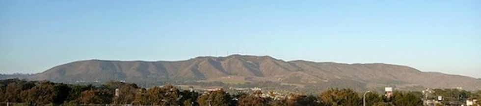
Most Bay Area locals have a tendency to take San Bruno Mountain for granted, a grassy, often fog shrouded lump looming alongside the Bayshore freeway. Situated just south of the San Francisco - San Mateo county line, it’s considered to be the northernmost peak of the Santa Cruz Mountains. The majority of the mountain lies within the 2,300 plus acres of San Bruno Mountain State Park, a unique open-space island in the midst of the north peninsula's dense urbanization. Its summit stands 1,314 ft high, and offers commanding 360-degree views of the entire Bay Area; you can see north to Marin County, Mt. Tamalpais and even see Pt. Reyes on clear day. To the southwest stands imposing Montara Mountain and to the east lie the massive peaks of Mt. Diablo.
A mountain this grand deserves to be climbed by any bicyclist worth his or her salt, and fortunately for us there is a paved road to the summit, put down to allow access to various telecommunication towers that dot the heights.
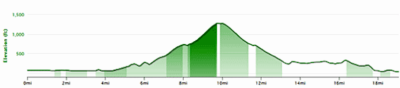
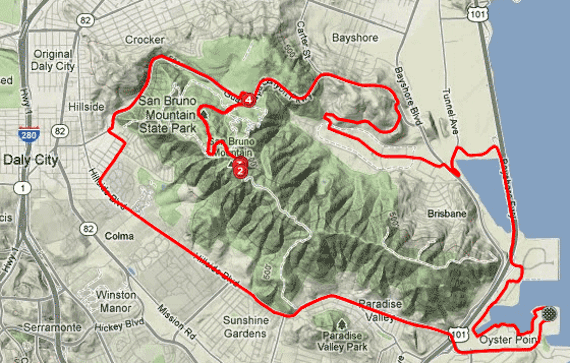
While there are numerous points to start this 19-mile loop ride, we’ve chosen to begin it from the public shoreline access at the end of Oyster Point Blvd. in South San Francisco (take the freeway exit on Hwy. 101 of the same name and drive east to the end of the road, public access parking is available on the periphery of Oyster Point Office Park). Starting here provides a good warm up before the six mile, challenging Cat 2 climb to the summit and also gives us a fine circumnavigation of the mountain itself.
Saddle up and begin the ride heading west, on the shoreline bike path, first passing the Oyster Point Marina and then various bio-tech office buildings until you reach Veterans Blvd. Here you’ll head to your right and ride past the Marriott hotel, either meandering on the bike path along the bay or being more direct and cutting thru the parking lots until you get to Sierra Point Parkway. Turn left at the four way stop intersection and continue under the freeway turning north, with the lagoon on your left. At the stop, go left on Lagoon Rd. for a quarter mile, and then make another left onto Tunnel Rd. at the T-intersection to cross over the CalTrain tracks and enter charming, hidden burg of Brisbane. As you approach the stoplight initiate a 180-degree turn to the right and head north on Bayshore Blvd. At the next light make a left onto Brisbane’s Valley Dr. for some great views of the mountain towering above you. After a hard dogleg right, make two more rights, first on Silverspot, then immediately on Mission Blue Dr. for a fast descent before a brief, but steep, romp up amongst the condos after which you’ll begin the real climb up Guadalupe Canyon Parkway at the stoplight, turning uphill (left).
Sweeping views of San Francisco will be your reward in less than 100 meters up this 6% section, and soon you’ll see the Cow Palace arena below you. While the sparse traffic on Guadalupe drives fast, the four lane road has a wide shoulder as you grind uphill. Continue straight at the stoplight and head up to the saddle summit crest, making a right turn into the park entrance. Restrooms are located just across the parking lot should you need them. Bear right on Radio Road, going under Guadalupe and begin the ascent to the summit through a thick eucalyptus forest, after which expansive views to the north open up as you turn south, the pitches varying from 8 to 12% in the 1.5 miles to the top, so you should be working up a good sweat, even on foggy and windy days (of which there are many). At this point you may hear some odd clattering in the wind – it’s the BART trains way down below going through Daly City. You’ll also note the road isn’t in that great a shape, which is good to remember on the fast return descent. Once you’ve reached the crest you’ll have an opportunity to really enjoy the vistas as you take a breather in the parking area. Retracing your route to the park entrance make a right on Guadalupe and head down into Daly City. For a few brief moments you’ll get taste of being in the country as you rocket down the canyon. At the second stop sign, make a left on Orange street, climb two blocks to the top and then make a right on Hoffman, skirting one of Colma’s many cemeteries. At the Hillside Drive stop sign make another left for a straight five mile shot back to Oyster Point with the wind at your back. Those seeking a more rigorous workout can turn around and reverse the course for a double summit and over 3000 feet of vertical. View details of the route on Strava.