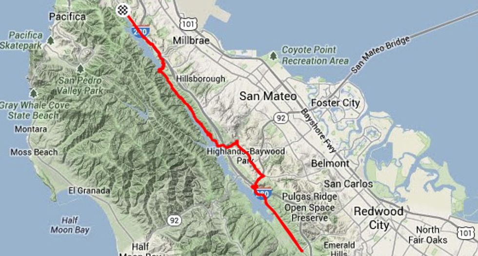
California is earthquake country - not exactly groundbreaking news - but the evidence is all around us in the Bay Area. As for the Bay Area's many faults, the most evident and certainly most prominent, is the San Andreas, running north-south parallel to the California coast for some 800 miles and separating the eastern North American plate from the counter clockwise rotating Pacific plate. It's easy to see on a satellite view of the state, running up from LA through the Salinas Valley, bisecting San Mateo County and through Marin County's Tomales Bay. Not that this has a lot to do with today's ride, other than to underscore the geologic underpinnings of our route. We'll cruise some fifteen or so miles directly above this seismic rift on a popular cycling route that includes a segment, like the fault itself, named after the lake where we begin our ride.
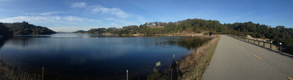
Access to the Crystal Springs Regional Trail trailhead is on Skyline Blvd. aka Hwy. 35. We started at the West end of San Bruno Ave.(from Hwy. 280 take Sneath Lane to Skyline). Restrooms are located a half-mile further down (and at many other points on the upper segments). The trail begins with an undulating descent and at the two mile point cyclist's need to detour at Larkspur Drive under Hwy. 280 for 3/4 of a mile. We get back on the trail at Hillcrest Blvd. at which point the trail plunges down to cross over San Andreas Lake dam where a left turns takes us to the Sawyer Camp segment of the path. Here it twists and turns through lovely oak forest and as it flattens out we reach the upper reaches of Crystal Springs Reservoir. Depending on the weather and day of the week there may be dense trail traffic of cyclists, joggers and walkers.
After nine miles we reach the trailhead at Crystal Springs Dam - currently the road over the dam is closed as the dam is being raised to increase reservoir storage capacity (it's estimated to reopen in the spring of 2015). Instead, we'll head down Crystal Springs Rd. under Hwy. 280. and at the stop sign, turn right onto Polhemus Rd. for a long two mile climb to the overpass above Hwy. 92 (there are wide shoulders on this road). Hang a right at the commuter parking lot and connect up with the Ralston Bike Trail to make a very scenic crossover of Hwy. 280 to drop into Cañada Rd. Here we'll head south for a fast, 2.5 mile cruise down to Edgewood Rd. On Bicycle Sundays, this segment of Cañada Rd is closed to vehicles. Reversing our direction at Edgewood at the 16.5 mile mark makes this a 33 mile roundtrip with 2,100 feet of climbing. Those wanting more can continue down Cañada Rd. to Woodside where they can hook up with the La Honda - Tunitas Creek ride we chronicled last August, to create an epic 100 mile, 8000 foot day.