Arguably one of the most scenic bike rides in the Bay Area, the 25-mile, world-class Stinson Beach loop has it all: incredible views, thrilling descents and nearly 3,000 feet of climbing. Plus it's just a short ride (or drive) away from San Francisco.
How to Get There
By Car: The Manzanita Park and Ride in Mill Valley, at the junction of Hwy. 101 and Hwy. 1, gives you ample space to warm up. To get there, take the Hwy. 1 Stinson Beach exit and make the first right onto Pohono St. Park here if there's space, otherwise turn left and traverse to the far side of the parking lot under the freeway bridge, where there is plenty of public parking.
By Bike: Head across the Golden Gate Bridge via Sausalito. At the north end of town jump onto the bike path that's parallel to the freeway.
Riding Directions
1. Head north on the bike path towards Mill Valley.
2. Where the path angles closest to the nearby road, go left through the posts and immediately turn right onto the Miller Ave. bike lane. (0.5 miles)
3. You'll continue, past the high school, onto Miller and into downtown Mill Valley.
4. Go left, then right, around the town plaza.
5. At the town clock, turn left onto Throckmorton Ave.
6. At the next stop sign, go left onto Cascade Drive into Old Mill Park, bearing right at the traffic circle to go up the canyon.
7. Take a left on Marion Ave. and wind your way up to Edgewood Ave. where you'll turn right and continue to climb up to Four Corners.
8. From Four Corners take a right turn onto Panoramic Highway and continue to climb up to the highest point of this ride at ranger station at Pantoll. The road to the right leads up to the top of Mt. Tam. This is a good spot use a restroom, fill a water bottle or put on a vest or jacket.
9. From the Pantoll, you'll make the 1,500-foot drop down to Stinson Beach. This awesome descent starts in the trees, with many tight turns, and then half way down, opens up to some amazing vistas of the Stinson Beach, Bolinas Lagoon and if it's a clear day, Pt. Reyes in the distance. Be aware of tight switchback turns and rough pavement, as well as wet corners in foggy conditions.
10. When Panoramic Hwy. tees into Hwy. 1 you'll go left (head right into Stinson Beach for an espresso and a fresh donut at the Parkside Café).
11. Going south on Shoreline Highway (Hwy 1) you'll begin a moderate climb that offers a nice overlook at the two miles of beach below.
12. Soon some of the nicest views to be had of San Francisco coast and distant Montara Mountain enter your field of vision. It may be a struggle to keep your eyes on the road ahead as there's so much competing for your attention.
13. Hugging the hillside, the road snakes in and out of a couple of gulches, then at the Slide Ranch, makes a steep, but short climb onto a ridge, offering even more amazing views of the Pacific to your right and Mt. Tam and Frank Valley to your left.
14. At the bottom of the fast descent down to Muir Beach, bear right to continue on Hwy. 1 for the 600 foot climb up Green Gulch.
15. A quarter mile past the top of the ascent you'll intersect Panoramic Hwy. From here, continue straight down Shoreline Highway to Tam Junction.
16. At the stop light, turn left, and a half-mile later you'll meet up with the bike path at the beginning of Miller Ave. Caution, you may be tempted to do it again, or ride it in reverse.
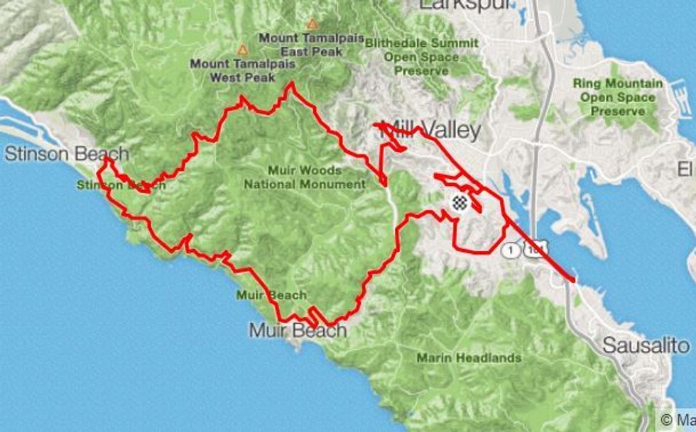 map via Strava.com