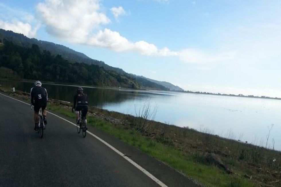
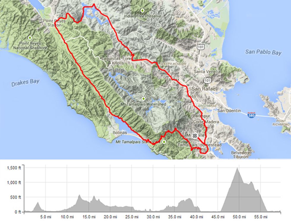
The counter-clockwise 56-mile loop up to Point Reyes Station takes in a wide variety of the roads and scenery that makes Marin such a special place to spin. There are a few challenging climbs in the 3,800 feet of elevation gain and you’ll have a number of excellent opportunities for pace-lining should you make this a group ride. Expect bucolic scenery and spectacular vistas.
Step by Step Directions
Begin at Studio Velo’s bike shop in downtown Mill Valley (31 Miller Avenue, Mill Valley)
- Head southeast on Miller Ave.
- Turn left at the traffic light onto Camino Alto (1.4 miles)
- Proceed straight at the 3rd light (2 miles)
- At the summit Camino Alto becomes Corte Madera Ave. (3.3 miles)
- At the stop, proceed straight on Magnolia Ave. through Larkspur and into Kentfield
- At the stop sign when Magnolia Ave. ends bear left onto Kent Ave. (6.5 miles)
- At the Ross commons make a left onto Lagunitas Rd. (7.4 miles) then immediate right onto Shady Ln.
- At Bolinas Ave. (8 miles) make a right then an immediate left at the light on San Anselmo Ave.
- At the intersection with Forrest Ave. and Center Blvd. (9.5 miles) go onto Lansdale Ave. (it parallels Center)
- At the end of Landsdale, Center becomes Broadway. Hop onto Broadway and go through Fairfax
- At the end of Broadway at the Library, there is a short bike path connector to Olema Rd. (10.6 miles)
- Turn left (carefully) on Sir Francis Drake Blvd. (11.6 miles) to begin a vigorous ascent over White Hill (7.1% 1 mile & 358 feet)
- After a fast descent turn right at the golf course onto Nicasio Valley Rd. (15.4 miles). Some fast riding through redwoods and horse ranchettes brings you out to Nicasio, where there are porta-potties and a small general store. (19.7 miles)
- Superb opportunities to form wicked fast pace lines soon appear as you skirt Nicasio Reservoir, slowing filling with our winter rains. Turn left at the intersection with the Point Reyes-Petaluma Rd. (23 miles).
- Maintaining speed, descend from the dam and make a right at Platform Bridge (26 miles)
- Remain on the Point Reyes-Petaluma Rd. until reaching Hwy. 1 at Point Reyes Station (29.2 miles).
- After fueling in PRS, head south out of town on Hwy. 1. Water and food are available in Olema (32 miles). Note Sir Francis Drake Blvd. on the left. Proceed straight on Hwy. 1 for an undulating and sometimes challenging (there a some short climbs) sprint down the Olema Valley.
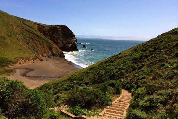
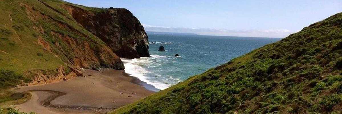
- A fast descent brings us down sea level to the Bolinas Lagoon (41.1 miles)
- Good pavement makes the ride into Stinson Beach a blast (45.8 miles)
- Leaving Stinson we’ll make a left onto the Panoramic Hwy. to begin the longest climb of the day (it’s rated a category 2), the 3.5 miles up to Pantoll (49.7 miles)
- The views northwest overlooking Stinson out to Bolinas, the Duxbury Reef and Point Reyes itself in the distance from the switchbacks are stunning
- From Pantoll (restrooms and water at the ranger station) it’s a long and gorgeous descent back down to Mill Valley along Mt. Tam's flanks.
- Go straight across at the major intersection called four corners (54 miles)
- Upon reaching Hwy. 1 make a left (54.9 miles)
- Continue to the stoplight at Tam Junction and making a left onto Almonte Ave. (57.5 miles)
- It’s a straight shot back into Mill Valley after Almonte becomes Miller at the high school football field.
Things to Do Before, During and After the Ride
Downtown Mill Valley has three coffee emporiums, the Depot Café, a Peets, and the new Equator, which also serves excellent gluten free waffles.
At mid-way, Point Reyes Station offers the always scrumptious Bovine Bakery, as well as good expresso at Toby’s Feed Barn if a full on lunch won’t slow you down, try the Station House Café. There’s also a grocery store and public restrooms a block over from Hwy. 1
Stinson Beach’s Parkside serves up fresh doughnuts from the outside coffee bar with table service inside. Bill’s Superette has groceries and a deli.
Mill Valley bike shop Studio Velo has created some special, limited run t-shirts (designed by Joe Kayser) to commemorate these classic Marin loops. Six shirts in all are in the works, each with a distinctive loop logo, the map on the backside of the shirt, and each comes with a laminated map of the ride.