This backpacking trip in the Grouse Ridge area of Tahoe National Forest is a fairytale landscape of alpine lakes, granite hills, and sugar pine forests. There are two ways to crush this trail: the easy way and the hard way.
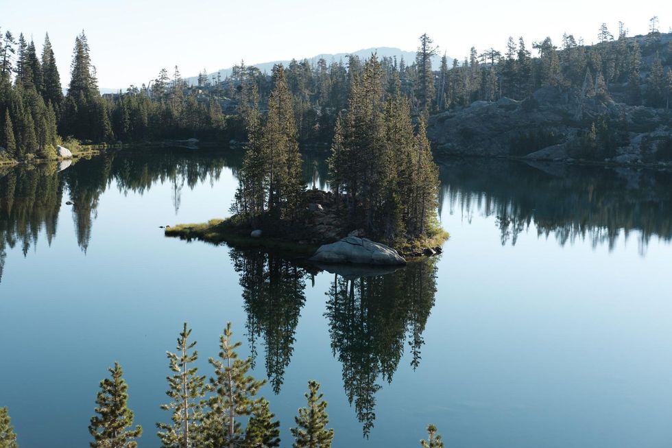
You’ll reach the ultimate prize the hard way at Glacier Lake, a lovely oblong pool nestled against a granite cliff, a meandering five-and-a-half miles from the trailhead. But if the elevation has you gasping, aim for pretty Island Lake instead, a beautiful expanse of blue dotted with rocky islets on a mostly flat trail just a mile and a half from the parking lot.
 (Courtesy of Outdoor Project)
What to Know about Grouse Ridge
There are a variety of hiking and backpacking destinations in Grouse Ridge but this route begins at the Carr Lake Campground off of Bowman Lake Road. Gear up in the parking lot, lace those boots tight, and step out onto the Carr Lake Trail. You’ll spend most of the first section of the hike skirting the corner of inviting, impossibly blue waters past Carr Lake and Feeley Lake, then heading uphill to reach Island Lake.
Find a campsite here —it’s dispersed camping, meaning you can camp just about anywhere as long as you are 100 feet from the water’s edge—and spend the rest of the day floating in the cool, clean water, or continue on towards Round Lake. About two-and-a-half miles from the trailhead, you’ll hit a junction. Stick to the Glacier Lake Trail for the way out; the more dramatic scenery of the Sand Ridge Trail makes for an impressive hike back.
It’s another four miles through the wilderness to reach Glacier Lake, the final section of which has quite a bit of moderate uphill trudging. It’ll all be worth it though when Glacier Lake finally comes into view. You won’t be alone up here, this is a popular backpacking spot, but Glacier is just secluded enough that it’ll feel almost like you’ve got the lake to yourself. It’s dispersed camping here, too, and you’ll find some already cleared, flat spots along the lake’s northwest side.
On your way back, take the Sand Ridge Trail for a view of a huge swath of Grouse Ridge. The mostly flat and downhill path reconnects with the Carr Lake Trail around Round Lake and takes you back to the parking lot.
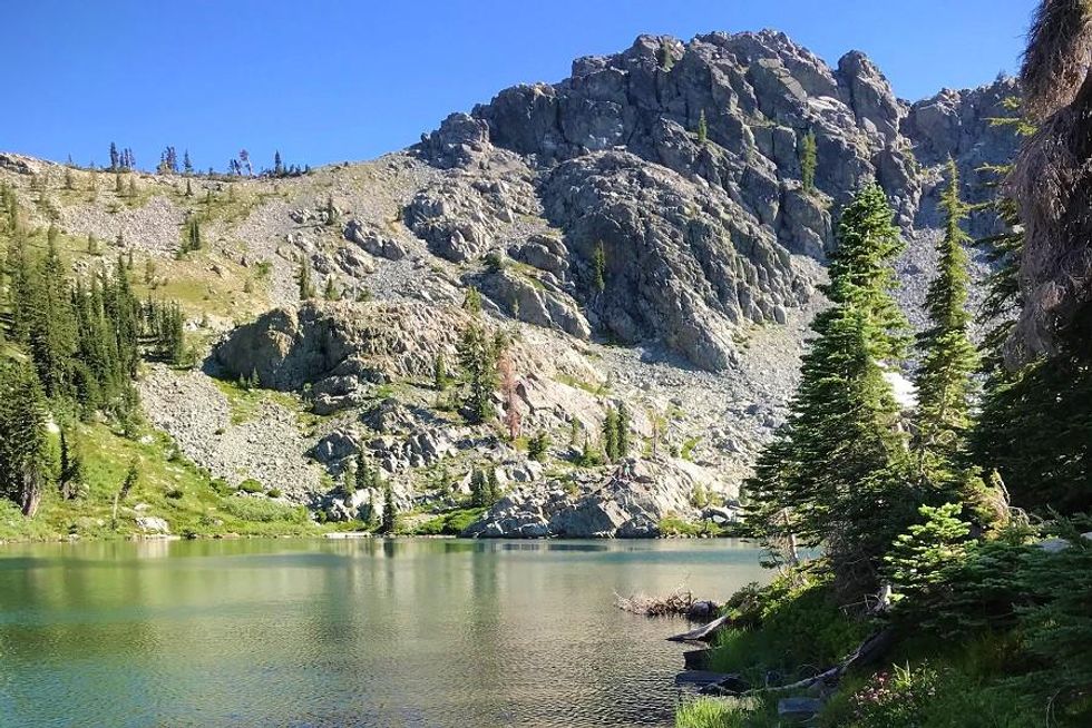 Destination 2: Glacier Lake, Tahoe National Forest(Shoshi Parks)
When to Visit
Unless you want to test your mettle, you’ll want to plan your backpacking trip to Grouse Ridge between late spring and early fall, when the snow has melted and the days are long. There is no need to reserve a site in advance or get a permit of any sort (unless you plan to do some fishing).
How to Get There
It’s a straight shot up Highway 80 towards Truckee to reach Grouse Ridge in this section of the Tahoe National Forest. Altogether, it’s about 177 miles and three-and-a-half hours from San Francisco, the last 30 minutes of which requires rolling slowly on an unpaved road.
From Yuba Pass on Highway 80, take Highway 20 for five miles to Bowman Lake Road. From there it’s a long and bumpy 11-plus miles to the Carr Lake Campground. A low-clearance vehicle will get you there, but you’ll find the way a little easier if you’re behind the wheel of a car or truck with higher clearance.