Back in 2022, we sat down and made a list of all the hikes we hoped to accomplish that year, one for every month. But 12 trails weren't nearly enough. By the time we reached December, we'd come up with a whole new set of hikes to add to our 2023 bucket list.
And now here we are, at the start of 2024, still dreaming of hitting the trails in Sonoma, the Sierra, and everywhere in between. From the Santa Cruz Mountains to the Berkeley Hills, here are our bucket list hikes for the coming year.
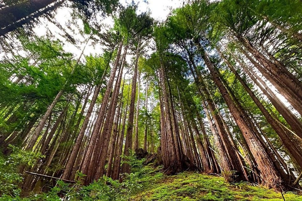
January: Land of Medicine Buddha, Loop Trail (5.6-mile loop)
(Courtesy of @nehasawant777)
This loop through the Land of Medicine Buddha, a gorgeous forest of old-growth redwoods at the heart of the Santa Cruz Mountains, is as spiritually satisfying as it is physically fulfilling. The hike begins with the Eight Verses Trail, which pairs the wisdom of the Buddha with benches for quiet contemplation. When you’re feeling relaxed and recentered, continue north along the loop, inhaling the natural beauty of the forest. By the time you reach the parking lot again, you’ll have a deep sense of wellbeing to carry with you into the new year. For the best chance at finding a parking spot in the tight, well-loved lot, start your hike in the early morning or late afternoon. // 5800 Prescott Rd. (Soquel), landofmedicinebuddha.org
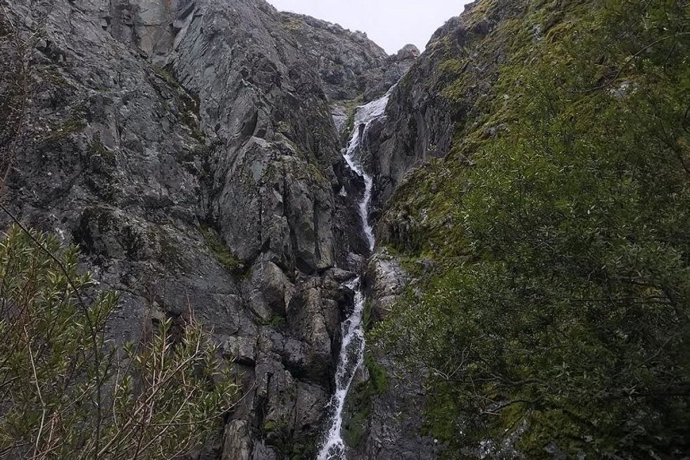
February: Del Valle Regional Park, Murietta Falls Trail (12.3 miles, out and back)
(Courtesy of @wuhikes)
Buckle up for an intense hike with an ephemeral waterfall that should be flowing fast come February. This hike to Murietta Falls climbs more than 4,000 feet in just over 12 miles but you’ll earn bragging rights for being one of the rare few to catch this skittish cascade, the highest in the Bay Area, in action. Although you’ll park at the Lichen Bark parking area at Del Valle Regional Park, the majority of the hike is actually in the Ohlone Regional Wilderness along the Ohlone Wilderness Trail (AllTrails breaks down each step in uncharacteristically refreshing detail; be sure to screenshot it in advance in case you lose cell service on the way). Note that you’ll need a hiking permit to access this hike, which you can purchase at the Del Valle Park entrance when you arrive ($2/person) or online at least seven days before you hit the trail ($4/person). // 7000 Del Valle Rd. (Livermore), ebparks.org
March: North Table Mountain, Phantom Falls Trail (4.2 miles, out and back)
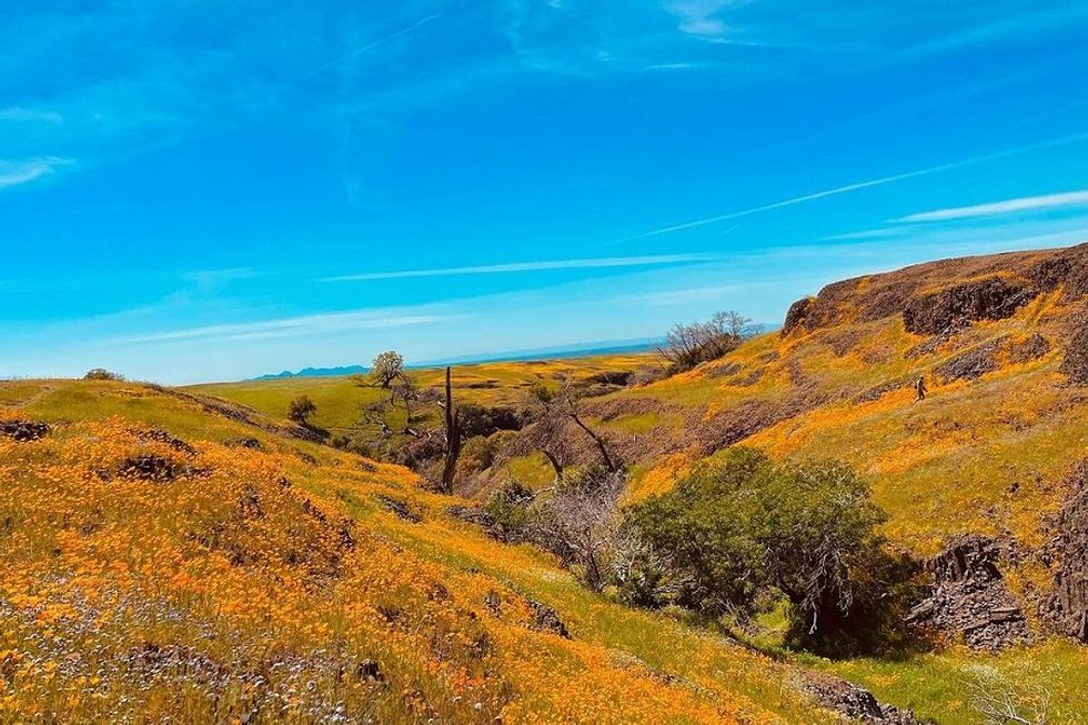
(Courtesy of @drewtravel1206)
All signs point to a rainy winter in 2024, which can only mean one thing come spring: A wildflower bonanza. Up in Butte County at North Table Mountain Ecological Reserve, aficionados of the colorful blooms will find one of the best arrays in the state from March through April. Catch the beauties turning their petals to the sun on the Phantom Falls Trail, a route which, as its name suggests, also has a seasonal waterfall (and four other cascades) that should be booming in spring. Pick up the trail from the North Table Mountain parking area and follow it all the way (about two miles) to the steep canyon over whose lip the waters fall. When you have enough photos to fill a million Instagram stories, backtrack the same way you came. // 2488 Cherokee Rd. (Oroville), wildlife.ca.gov
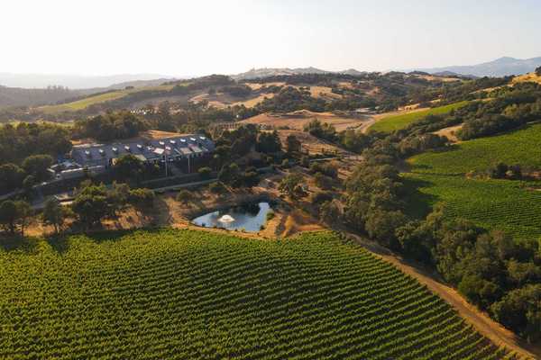
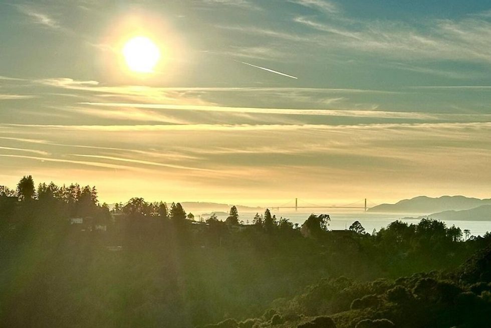
April: Sonoma Coast State Park, Islands in the Sky (4-mile loop)
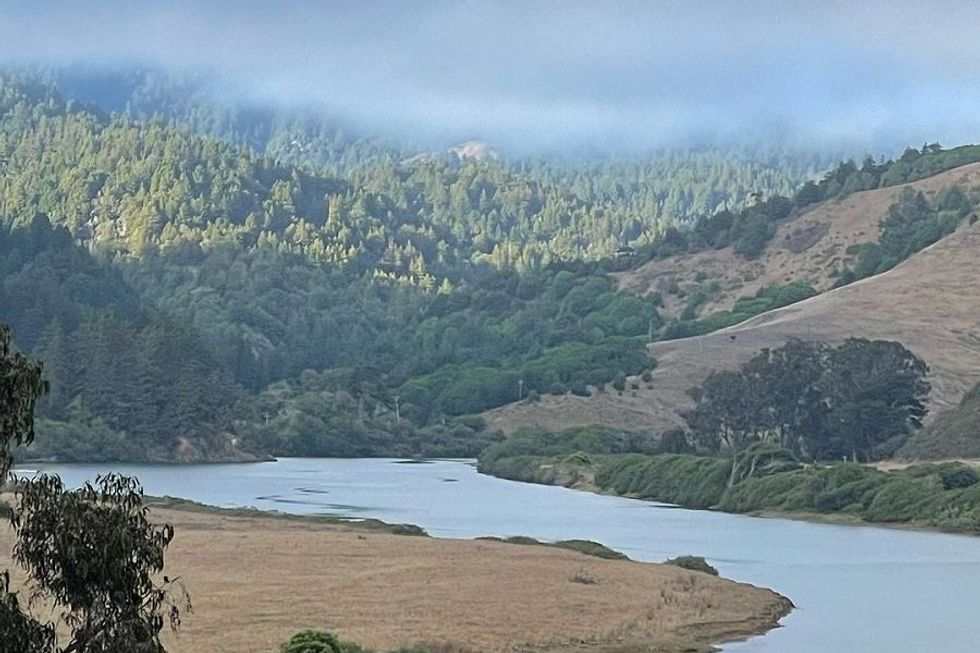
Looking towards the foggy hills that conceal the Islands in the Sky.
(Courtesy of @pablobeck)
On foggy days, the steep slopes that stretch from this trail’s summit into the clouds above float like islands in the sky. But even when it’s sunny, the meadows at the top of this steep forest climb seem like they were placed there by some benevolent deity. The trail starts at the Russian River and passes through pasturelands to the Islands in the Sky Vista Loop. Take a right and follow the path up, up, ever up, to its highest point. Once there, you can hike around on the relatively flat, golden grasslands or head right back down the mountain along the now-defunct Upper Freezeout Road. Opt for the former if it’s a clear day; you’ll have views all the way to the Pacific. // Freezeout Flat Rd. (Jenner), parks.ca.gov
May: Purisima Creek Redwoods Open Space, Whittemore Gulch + Harkins Ridge (6.5-mile loop)
(Courtesy of @thesfpeninsula)
This 6.5-mile hike near Half Moon Bay has delicious views, shady redwood groves, and babbling creeks. But don’t let the pretty environs trick you into thinking it’s easy—it’s not, and that’s part of what makes it worth a spot on this year’s bucket list. From the North Ridge Trailhead, keep right onto the forested switchback trail instead of the steep bike-friendly path. At the junction, keep left onto the Harkins Ridge Trail then the Whittemore Gulch Trail before popping back out on to the North Ridge Trail. Watch your step, especially after a late spring rain—this is banana slug territory. // Hwy 35 (Half Moon Bay), openspace.org
June: Desolation Wilderness, Echo Lakes Trail/Pacific Crest Trail (5.3 miles, out and back)
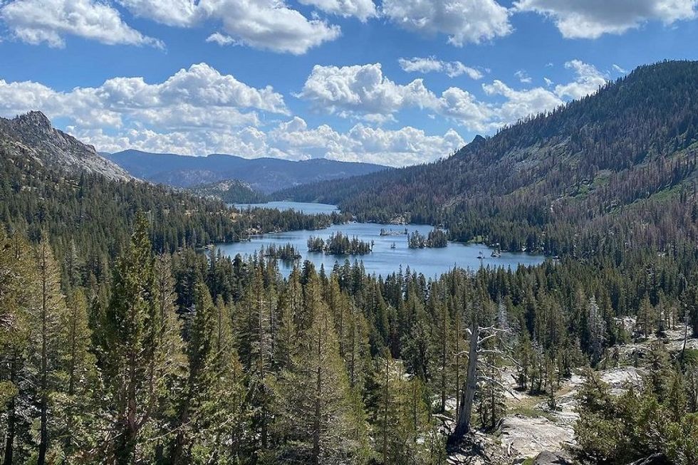
(Courtesy of @undrcvrmermaid)
Alpine lakes and endless mountain vistas make South Lake Tahoe’s Echo Lakes Trail—a section of the Pacific Crest Trail—one of the area’s best hikes. With an elevation gain of only around 500 feet, it’s also one of the more gentle trails in the Sierra. Head into the Desolation Wilderness from the Echo Chalet on the southern end of Lower Echo Lake, picking up a free permit at the trailhead. The trail skirts its eastern shore then continues on to Upper Echo Lake. // 9900 Echo Lakes Rd. (Echo Lake), fs.usda.gov
July: Mammoth Lake, Devil’s Postpile and Rainbow Falls (12.8 miles, out and back)
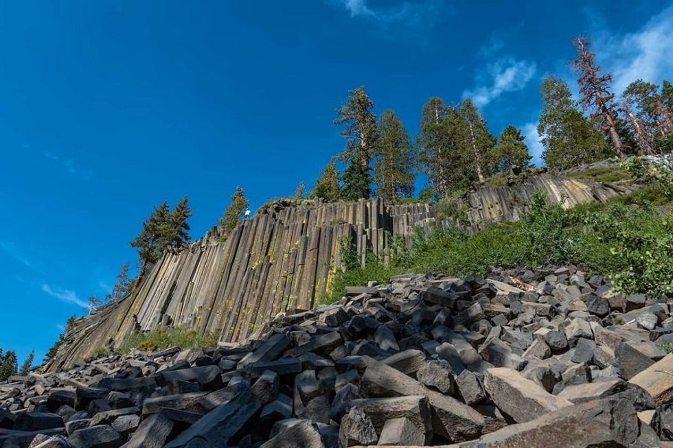
(Courtesy of @alsroadtrips)
This trail in the Eastern Sierra isn’t easy. Not only will you gain more than 2,500 feet of elevation along the way, at 8,955 feet above sea level, you’ll be oxygen challenged even before you start. But take it slow and you’re in for a treat: a full day of crystalline lakes, rushing waterfalls, and the spectacularly odd Devil’s Postpile rock formation. If you begin your hike before 7am, you’re allowed to drive up to the trailhead. Otherwise, hop on the free shuttle from nearby Mammoth Village and take it to the Horseshoe Lake Trailhead (just be back for the last bus at 7pm). Follow the Mammoth Pass Trail a little over two miles before turning left onto the Rainbow Falls-Wagon Trail. Continue all the way to the waterfall then, after a leisurely lunch, head back out and veer left towards Devil’s Postpile. The same trail will loop you around to the Mammoth Pass Trail, and send you back to the trailhead and shuttle bus stop. // 4500 Lake Mary Rd. (Mammoth Lakes), visitmammoth com
August: Tahoe National Forest, Sierra Buttes Trail (5.1 miles, out and back)
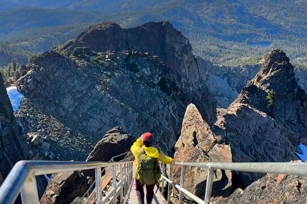
(Courtesy of @honeyoats_adventure)
In the early 20th century, more than 150 fire lookouts helped California’s park rangers keep an eye on dangerous wildfires. Technology has since put most of them out of commission, but a handful of the original lookout cabins remain to welcome hikers (and even overnight guests). On the northwestern side of the Tahoe National Forest, the Sierra Buttes Fire Lookout sits high on its granite throne about 2.5 miles (and 180 steep metal steps) from the trailhead. There’s just one trail, the Sierra Buttes Trail, to worry about, and it’s an intense one. But if you ask us, the views that reach all the way to Mount Lassen on a clear day are worth the pain. // Monarch Rd. (Downieville), fs.usda.gov
September: Mount Sutro Open Space, Mount Sutro to Twin Peaks (3.8-mile loop)
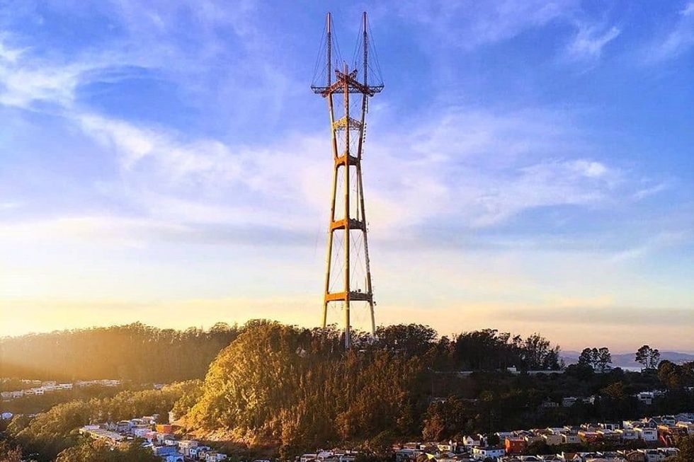
(Courtesy of @sfsutrotower)
As the summer gloom turns to clear September skies, Mount Sutro and Twin Peaks emerge from the fog. It’s a perfect time to hike the iconic hills and take in the views of the city below. Pick up Sutro’s Historic Trail from the corner of Stanyan and 17th Street. It’ll take you on a circuit around the mountain’s summit then send you back down John Stone Drive and across Clarendon Avenue to the Sutro Tower Trail. At its end at Twin Peaks Blvd, the climb begins again. Circle the sibling peaks then either return the way you came or loop back to your starting point on city streets. // Stanyan & 17th St. (Twin Peaks), ucsf.edu
October: El Corte de Madera Open Space, Tafoni Sandstone Loop via Methuselah Trail (6-mile loop)
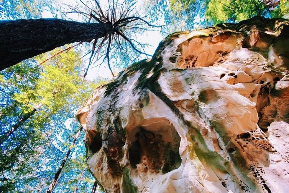
(Courtesy of @madelinetheexplorer)
El Corte de Madera Creek Open Space Preserve is a beautifully shaded park perfect for hiking in the early fall, while the heat of the summer lingers. The six-mile loop (which uses this 4.6-mile route as a foundation) coils around two of the Bay Area’s most precious natural wonders: the Tafoni Formations, ancient deposits of honeycombed sandstone, and the Methuselah Tree, the oldest, most humongous redwood in the Santa Cruz Mountains outside of Big Basin (which is, itself, a precious local natural wonder). Start from the Methuselah parking lot, checking in on the massive tree before following the Methuselah Trail west to the Fir Trail. From there, take the loop to the left and continue onto the Tafoni Sandstone spur trail. When you’ve had enough of the geological behemoth, return to the Tafoni Trail, veering left to follow the Sierra Morena Trail back to the parking lot. // CA-35 & Skyline Blvd. (Redwood City), openspace.org
November: Tilden Regional Park, Inspiration Point to Wildcat Peak (4.2 miles, out and back)
(Courtesy of @geechsorensen)
Prepare for the coming holiday with a gorgeous trail that’s close to home—and easy enough to do when family is in town. Nestled in the Berkeley hills, Tilden Regional Park is all towering sequoias and expansive views over the sparkling bay. Pick up the trail at Inspiration Point and follow the paved Nimitz Way to Wildcat Peak Trail almost two miles down. From there, you’ll pass through the Rotary Peace Grove, a quiet congress of trees dedicated to the region’s activists, before continuing another quarter mile to the Wildcat Summit. Complete the hike by backtracking the way you came, a total hike of just over four miles. // 2501 Grizzly Peak Blvd. (Orinda), ebparks.org
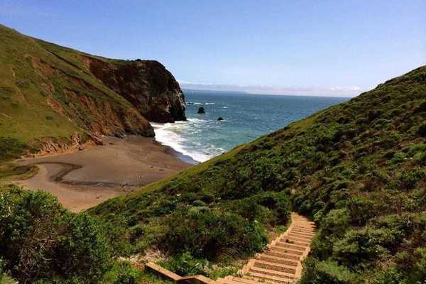
December: Golden Gate National Recreation Area, Bolinas Ridge Trail (12.4 to 22 miles, out and back)
(Courtesy of @embering)
Send 2024 packing with the biggest, baddest hike of the year. West Marin’s Bolinas Ridge Trail is one of the crowning glories of the region’s extensive trail system, a path that ripples like ocean waves along the San Andreas fault. Park at the Bolinas Ridge Trailhead off of Sir Francis Drake Boulevard in Olema and begin the hike south. If you’re up for the whole shebang, you’ll steadily climb up then back down again over 11 miles of trail to the Fairfax-Bolinas Road, before turning around and doing the same thing on the way back. If 22 miles in a day is a little daunting, cut the route in half by turning around at the Randall Trail a little over six miles from the Bolinas Ridge trailhead. Whichever you’re up for, the views will not disappoint. From the sapphire waters of Tomales Bay in the hike’s first couple miles to those of the Bolinas Lagoon near the trail’s end, this hike is one of Marin’s best. // Sir Francis Drake Blvd. (Olema), nps.gov/goga