Made up of nine different counties, the Bay Area has a vast and varied landscape with endless trails waiting to be explored.
We’ve chosen one hike to encapsulate the beauty of each region, from the coastal bluffs of San Mateo, San Francisco, and Marin to the oak forests and grass-and-wildflower-carpeted hills of Alameda and Contra Costa.
Don’t miss these nine quintessential trails, one for each county.
Tennessee Valley Coastal Trail to Pelican Inn, Marin County
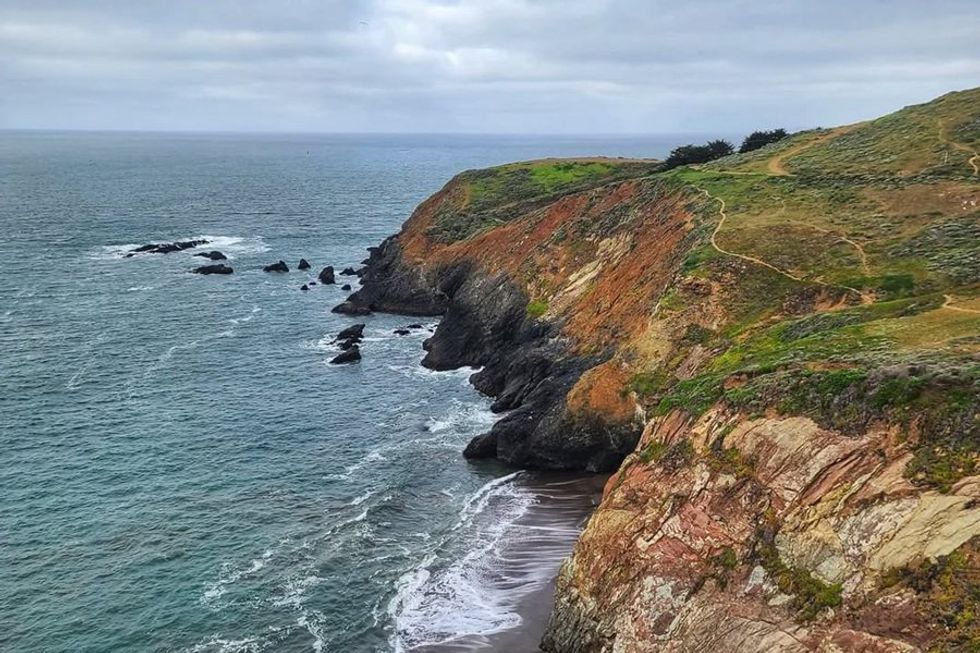
Stunning views along the Tennessee Valley Coastal Trail in Marin County.
(Courtesy of @bayareahikes)
In a county full of spectacular trails, this hike in the Golden Gate National Recreation Area holds its own, with dramatic coastal bluffs and unsurpassed views of the Pacific. From the Tennessee Valley Trailhead, wind your way up over the coastal trail and across its seaside ridge, before heading down the hill towards a mid-hike reward: Pints at a charming English pub, the Pelican Inn. When you’ve drained your glass, hike back up out of Muir Beach; even though it’s the same trail you came in on, somehow the shifting landscape makes it feel almost like a different hike on the way out.
Distance: 8.2 miles out-and-back
// 591 Tennessee Valley Rd. (Mill Valley), nps.gov/goga
Año Nuevo Point Trail, San Mateo County
This trail along one of San Mateo’s most dramatic coastlines is part hike, part wildlife safari. Año Nuevo State Park is famous for its winter residents, the elephant seals who come ashore to mate and raise their young. But the beach is an ideal spot for catching sight of other pinnipeds, whales, and sea birds all year-round. Hit the trail from Año Nuevo State Park Road, following it north to the elephant seal stomping (er…scooting) grounds 1.5 to 2 miles from the trailhead. Pick up a free, first-come first-served permit to access the trail from April through November; from December through March, the hike can only be done with a park guide (visit their website for reservations).
Distance: 3 to 4 miles out-and-back
// Año Nuevo State Park Rd. (Pescadero), parks.ca.gov
Inspiration Point to Wildcat Peak, Alameda County
Berkeley’s Tilden Regional Park is beloved for a variety of reasons, not the least of which are its giant sequoias and impressive 360-degree views. This easy trail takes you to both. From the appropriately named Inspiration Point, follow the paved Nimitz Way about two miles to the Wildcat Peak Trail. Pass through the Rotary Peace Grove, where each massive redwood is dedicated to an activist or organization, then continue another quarter mile to the summit, where you can take in the entire Bay from the huge stone bench put in place for just that purpose.
Distance: 4.2 miles out-and-back
// 2501 Grizzly Peak Blvd. (Orinda), ebparks.org
Sindicich Lagoon Loop, Contra Costa County
With its rolling hills and deep blue ponds, beautiful Briones Regional Park is pretty as a painting—especially after the rain. On this trail, you’ll hike across emerald (or gold, depending on the season) meadows splashed with colorful wildflowers as you slowly climb the Abrigo Valley Trail to the Briones Crest Trail and its Sindicich Lagoons. Picnic there on the water’s edge, with views that stretch out over the Carquinez Strait, before completing the 5.7-mile loop.
Distance: 5.7 mile loop
// Bear Creek Staging Area, 1611 Bear Creek Rd. (Lafayette), ebparks.org
Lands End Trail, San Francisco
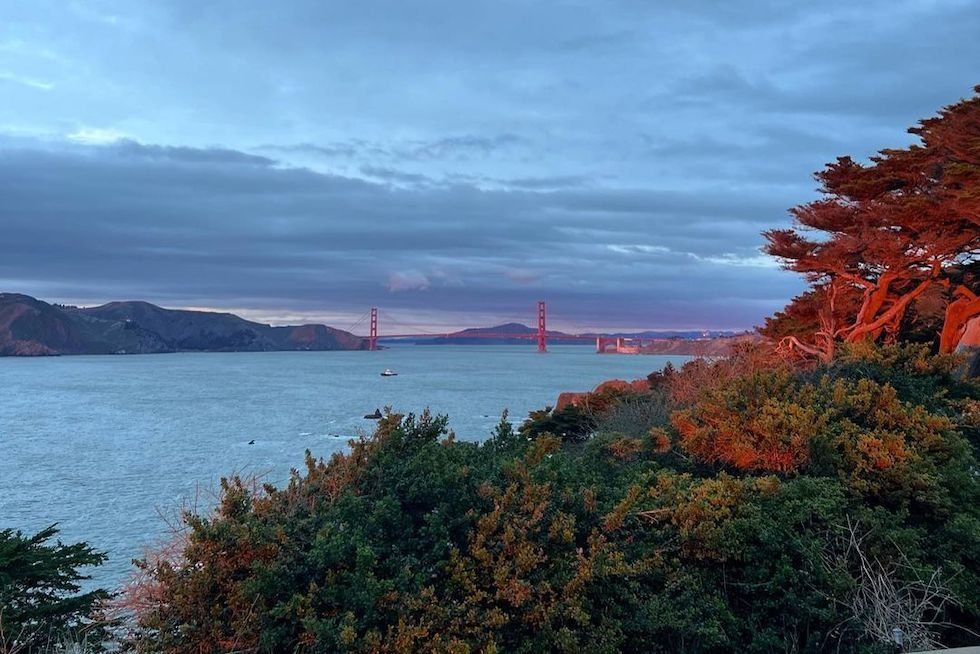
A view of the Golden Gate from SF's Lands End Trail.
(Courtesy of @outsidelands_sf)
This quintessential SF hike isn’t just a heart-pumping trail, it’s a journey to some of the west side’s most interesting landmarks and viewpoints. The Lands End Trail loop itself is a gorgeous three-mile route through the Presidio and along the coast. But if you’ve got a little extra time and energy, it’s well worth it to head to at least some of the nine short detours along the way. Stops like Mile Rock Beach and the Sutro Baths will make your hike all the more memorable.
Distance: 3- to 4.5-mile loop
// Lands End Trailhead, Merrie Way (Outer Richmond), nps.gov/places
Mount Umunhum Summit Trail, Santa Clara County
This moderately challenging hike sweeps you up through the Santa Cruz Mountains to the eight-story radar tower at the summit of Mount Umunhum. The 3.7-mile trail (one way) switchbacks its way from the Bald Mountain parking lot, steadily climbing through oak and manzanita scrub before opening up to views that ripple from the Sierra Azul all the way to San Francisco.
Distance: 8.4 miles out-and-back
// Mt. Umunhum Rd. (Los Gatos), openspace.org
Skyline Trail, Napa County
One of the most popular parks in the Napa Valley, Skyline Wilderness is a lovely landscape of sloping hills and sun-dappled oak forest. On the Skyline Trail, you’ll roll through the landscape all the way to Lake Marie, a sapphire jewel nestled between the low peaks, before looping back toward your starting point. The view, which reaches across Napa to Mount Tam in Marin, will enchant you throughout the hike. Pro tip: Go counter-clockwise to make the climb less painful.
Distance: 6.2-mile loop
// 2201 Imola Ave. (Napa), skylinepark.org
Goodspeed-Natkemper Trail to Hood Mountain, Sonoma County
The Mayacamas, the lovely, low mountain range that borders the Sonoma Valley, boast some of the best hiking in the county. On the Goodspeed-Natkemper Trail, you’ll travel more than 2,000 feet up Hood Mountain through some of its more dramatic landscapes, including pygmy forests and exposed rock faces. Hit the trail from Adobe Canyon Road across from the boundary of Sugarloaf Ridge State Park, then wind your way into Hood Mountain Regional Park all the way to the summit.
Distance: 7 miles out-and-back
// 2605 Adobe Canyon Rd. (Kenwood), parks.ca.gov
North Ridge to Saddle Trail Loop, Solano County
Hike with a herd at Solano County’s Lynch Canyon Open Space. The classic Northern California landscape, with its rolling meadows and groves of buckeye and oak, is also the home of curious cattle who will keep an eye on your progress. The route begins at the parking lot on Lynch Road. From there, head west toward the Tower and North Ridge Trails. For a shorter hike, take the Middle Valley Trail back to your starting point or loop around on the Ken Poerner Trail. The latter adds about two miles to the former’s 5.2-mile total. Skip this trail mid-week; the park is only open Friday through Monday.
Distance: 5.2- to 7-mile loop
// 3100 Lynch Rd. (Fairfield), solanocounty.com