Sick of crowded studio classes and repetitive fitness machines?
Switch up your workout without sacrificing any of its intensity with a climb up the Bay Area’s tallest hikeable peaks.
From 2,463-foot-tall Sonoma Mountain in Glen Ellen to 4,342-foot-tall Mount Saint Helena in Calistoga, bagging these mountains will have you working muscles you forgot you had. Our advice? Don’t forget to stretch.
Mount Saint Helena, Calistoga
Elevation: 4,342 feet
Hike length: 9.7 miles out-and-back
The highest climbable peak in the Bay Area, this hike up Mount Saint Helena will give you a whole new perspective on Napa County. It’s a heart-pumping five miles to the summit where you’ll gain more than 2,000 feet of elevation but never fear, every time you need a break, those panoramic views will be there to keep you company.
Need to know: Mount Saint Helena is located in Robert Louis Stevenson State Park. The hike follows the Stevenson Memorial Trail (named for author Robert Louis Stevenson who honeymooned here in 1880) for about a mile before turning on to the wide Mt. St. Helena Trail.
// Robert Louis Stevenson State Park, 4824 Lake County Hwy #4774 (Calistoga), parks.ca.gov
 Mount Diablo in Walnut Creek(Larry Porter and Scott Hein; courtesy of @savemountdiablo)
Mount Diablo, Walnut Creek
Elevation: 3,849 feet
Hike length: 7 miles out-and-back
The Summit Trail to the top of Mount Diablo, the East Bay’s tallest, hikeable peak, is notoriously challenging—especially in the heat of the summer. But despite the 2,000 foot+ climb, doing this hike in the cooler months is as visually spectacular as it is physically rewarding. Just keep reminding yourself that the second half is all downhill.
Need to know: Enter the park via the South Gate Road to reach the Summit Trailhead. There’s a $10 day use fee to enter Mount Diablo State Park. Not far from the trail’s highest point at the summit is a visitor center with interactive displays and a gift shop that’s worth checking out.
// Mount Diablo State Park, 2675 Mt. Diablo Scenic Blvd. (Danville), parks.ca.gov
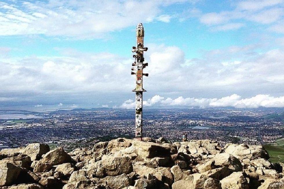
Mount Umunhum, Los Gatos
Elevation: 3,486 feet
Hike Length: 8.3 miles out-and-back
One of the highest peaks in the Santa Cruz Mountains, Mount Umunhum has been an important landmark for the Ohlone people since time immemorial (its name means “resting place of the hummingbird”). The construction of a boxy radar tower at the summit during the Cold War added to the mountain’s distinction, making it instantly recognizable from nearly anywhere in the South Bay. This 8.3 mile out-and-back takes you straight to it.
Need to know: The way to the summit starts at the Bald Mountain/Mt. Umunhum Trailhead and climbs along switchbacks for 1,200 feet. Parking at Bald Mountain is limited so arrive early to snag a spot. If you’re interested in learning more about the mountain’s natural and human history, download the free audio guide before heading out.
// Mt. Umunhum Rd. (Los Gatos), openspace.org
Mount Sizer, Morgan Hill
Elevation: 3,216 feet
Hike length: 15.2 miles loop
At 3,216 feet high, although Mount Sizer isn’t the highest peak on our list, it is far and away the most challenging, with an absurd 4,250 foot elevation gain (don’t ask us about the math). But along with the mettle-testing trail comes a solitude you’re unlikely to find on any other route due to the enormous size and relatively low visitation found at Henry W. Coe State Park. All the same, you’ll definitely want to start this one early. With all the oxygen breaks you’ll need, it’ll take you most of the day.
Need to know: This hike is best in the spring when the wildflowers are popping but avoid it at all costs in summer when the intense heat sets in. Park at the Henry W. Coe Visitor Center then follow Dunne Avenue north to Manzanita Point Road and the sign for the Monument Trail.
// 9000 E. Dunne Ave. (Morgan Hill), parks.ca.gov
 Hood Mountain in Kenwood is 2,730 feet high(Courtesy of @checkeb25)
Hood Mountain, Kenwood
Elevation: 2,730 feet
Hike length: 8.4 miles out-and-back
Hood Mountain in Sonoma’s southern Mayacamas Mountains holds all kinds of surprises, from its pygmy forests to its dramatic rock face to its blooming spring wildflowers. There are actually three trails that wind to the peak’s highest point but two are currently out of commission. The remaining route, the Goodspeed-Nattkemper Trail, is a little over eight miles with more than 2,000 feet of elevation gain.
Need to know: Access the Goodspeed-Nattkemper Trail from Adobe Canyon Road. The trailhead is on the left hand side just across the Sugarloaf Ridge State Park boundary. Parking is free.
// 2605 Adobe Canyon Rd. (Kenwood), parks.ca.gov
Mount Tamalpais, Mill Valley
Elevation: 2,571 feet
Hike length: 13.3 mile loop
Mount Tam has no shortage of gorgeous hikes but, to truly bag the peak, only the Summit Loop will do. We’re not gonna lie, the hike is pretty brutal, with a 2,349 foot elevation gain over 13.3 miles. But the payoff—views that stretch out over the Pacific and bay—is unbeatable.
Need to know: This hike begins and ends at the Blithedale Summit Trailhead and is primarily made up of unpaved fire roads. A day use parking pass ($8) is required to visit the Mt. Tam Watershed. Pick one up at the entrance kiosk at the Sky Oaks Headquarters or buy an annual pass online.
// Blithedale Summit Trailhead, 535 W. Blithedale Ave. (Mill Valley), marincountyparks.org
Mission Peak, Fremont
Elevation: 2,520 feet
Hike length: 5.8 mile loop
This hike up one of the South Bay’s tallest peaks is not for the faint of heart. You’ll gain 2,135 feet in elevation in less than six miles on the Mission Peak Loop—and all that without a shade tree in sight. But, as always when it comes to peak-bagging, the reward is an epic one: crystal clear views of the entire Bay Area.
Need to know: The Mission Peak Loop trailhead begins at the Stanford Avenue staging area of the Mission Peak Regional Preserve. Parking is tight so get there early to avoid having to park on residential streets further down the hill. Since there’s virtually nowhere to hide from the sun, this hike shouldn’t be attempted in the summer.
// 43600 Mission Blvd. (Fremont), ebparks.org
 Views from the summit of Mission Peak in Fremont(Courtesy of @missionpeakhikes)
Sonoma Mountain, Glen Ellen
Elevation: 2,463 feet
Hike Length: 7.6 to 8.3 miles out-and-back
The hike up Sonoma Mountain comes with a literary pedigree courtesy of Jack London. It’s a little over eight miles to the top of the steep Sonoma Mountain Trail which, not surprisingly, is located in Jack London State Historic Park, but the trail is mostly shaded. You can also get to the summit from North Sonoma Mountain Regional Park on the North Sonoma Mountain Ridge Trail, which is just slightly shorter at about 7.6 miles.
Need to know: Hit the trail in Jack London State Historic Park from the Beauty Ranch parking area. There’s a $10 fee to park but it includes admission to the park’s museum and cottage. In North Sonoma Mountain Regional Park, the trailhead is accessible from the main entrance. Parking is $7.
// Jack London State Historic Park, 2400 London Ranch Rd. (Glen Ellen), parks.ca.gov or North Sonoma Mountain Regional Park, 5297 Sonoma Mountain Rd. (Santa Rosa), parks.sonomacounty.ca