
While it can be difficult to reconcile the fact, Bay Area outdoor enthusiasts should appreciate the long-term US military occupation of the lands surrounding the Golden Gate. Because without the Army’s ongoing stewardship (however good or bad that was), these lands would have been developed for housing after the opening of the Golden Gate Bridge and the Golden Gate National Recreation Area might never existed.
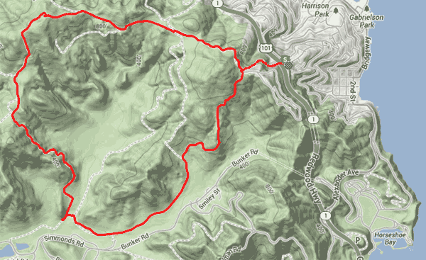
Our seven mile hike today will lead us on a lovely ridge top tour, giving us sweeping views of Marin Headlands, Mt. Tamalpais, lovely Gerbode Valley and, on clear day, faraway Pt. Reyes and the Farallon Islands. We’ll start high atop Sausalito’s Wolfback Ridge, heading on the Alta Trail to the hike’s highpoint at one thousand feet, and then descending around the Northwest rim of Gerbode Valley into neighboring Rodeo Valley for a spirited climb back up to the ridge. We’ll climb1600 vertical feet in total.
Access is easy from Highway 101 at the Spencer Ave exit, just north of the Waldo Tunnel. As parking can be limited on Wolfback Ridge, we suggest parking near the fire station at Spencer Avenue (also a bus stop for Golden Gate Transit) and hiking up the Wolfback Ridge Road overpass. The trails begin after the crest when WBR Rd. makes a 180 degree turn to the left. Head right on the aforementioned Alta Trail. At the junction go left, then immediately right on the Bobcat Trail fire road. We’ll head uphill passing the intersection on the right with the Marincello fire road from Tennessee Valley. Here the trail becomes the Miwok and we soon reach the FFA beacon and our high point (for altitude). Drink in the stunning views of the Bay and the Pacific before a fairly long descent down to Rodeo Valley. We’ll pass two connecting trails on the way down, the Old Springs that connects to the horse stables in Tennessee Valley and shortly thereafter the trail up to Hill 88, site of Nike missile radar station in the 1960s.
As we approach the lowest point of our hike at the entrance to Gerbode Valley we make a left turn on a short connector to the intersection of the Bobcat and Rodeo Valley Trails. Both will return us to our starting point, but for this hike we’ll head right and start a vigorous climb to the ridge above. As you look back into the quiet solitude of Gerbode Valley it’s difficult to believe there a million plus people and a whole lot of commotion just few miles away.
On weekends, this hike can also be accessed by SF Muni bus 76 that goes over to the GGNRA - pickup the hike at the low point at the entrance to Gerbode Valley.